
Page 10 - Black Bay Vision Plan
P. 10
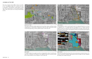
LOOKING AT THE SITE


        The series of diagrams depict different elements that affect
        the site. The diagrams range from a regional scale down
        to site specific. The information includes elements outside
        and inside the site that inform the formal design proposals.
        These studies where used as tools during the initial design
        process.


        .


                                                                   REGIONAL STUDY:                                                                        CIRCULATION:
                                                                   This analysis explores the existing regional amenities and open spaces, and their proximity  Understanding how visitors move through the site, the existing trail hierarchy was critical
                                                                   to Black Bay Park. It expanded our understanding of the city context, other parks and their  to understand how it is currently being used and explored. From this analysis it became
                                                                   associated programming, and their potential impacts on Black Bay Park.                 apparent that the most active trails were the paved systems that create a spine to the park,
                                                                                                                                                          but minimize access to and limit user experiences of the more naturalized areas throughout
                                                                                                                                                          the western half of the park.


                                                                  PARK ENTRY:                                                                             PARK ZONES:
                                                                  This analysis explores how people access the site. Organized by modes of travel it became   Park zones were defined based upon the varying environments and natural features. This
                                                                  clear that an enhanced arrival sequence and additional access points providing access   analysis informed how proposed design features should be folded into and/or celebrate
                                                                  from the west would be critical to long-term success of the Park.                       the existing micro-habitats of the park.


        VISION PLAN 10