
Page 11 - Black Bay Vision Plan
P. 11
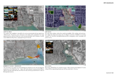
SITE DIAGRAMS


                                                                                                                                                                                       .


        EXISTING AREAS:                                                                         PARK EDGES:
        This analysis was completed to help define the various environments and user experiences  The park edge analysis outlines the overall permeability of the existing park perimeter.
        within the park. The primary zone is the park’s more native areas comprised of the large  Each edge was categorized based upon the degree of porosity or limitation to accessing
        gneiss formations with pine forest and moss/lichen ground plane, with a diversity of smaller  the park. This information included boundaries such as, topography, water, ownership, and
        zones labeled by the primary use/programming for that area.                             points of entry.


        RIVERFRONT ACCESS + VIEWPOINTS:                                                         BAY ACCESS:
        The relationship to the water and visual and physical connectivity to the river are important   Bay access differed from the riverfront access in that it looked at the degrees of access
        experiences within Black Bay Park.  Areas with higher physical access provide different   along with the programming based upon shifting water levels in the bay.
        opportunities than areas that are cut off from the river, but may provide dramatic views of
        this important amenity.
                                                                                                                                                                                                                                BLACK BAY PARK